Note: This article reflects publicly available monitoring updates and reporting available as of May 27, 2026. Volcanic conditions can change quickly, so travelers and residents should always follow official Icelandic safety guidance.
Iceland is once again doing what Iceland does best: reminding everyone that “land of fire and ice” is not a cute tourism slogan. It is a geological job description. On the Reykjanes Peninsula, southwest of Reykjavík, scientists are closely watching renewed volcanic unrest near Svartsengi and the Sundhnúkur crater row, where magma has continued to accumulate beneath the surface. The latest official monitoring update reported steady ground uplift, low but ongoing seismic activity, and approximately 26.6 million cubic meters of magma accumulated beneath Svartsengi since the most recent eruption began in July 2025.
That does not mean lava will burst out before you finish your coffee. Volcanoes are dramatic, but they are not always punctual. It does mean that Icelandic authorities, scientists, emergency teams, infrastructure operators, and tourism businesses are preparing for the possibility of another eruption in a region that has already seen repeated volcanic activity since 2021. The most likely scenario, according to monitoring trends, is a new magma intrusion that could move from Svartsengi toward the Sundhnúkur crater row and potentially reach the surface as a fissure eruption.
For readers trying to understand what is happening, the short version is this: Iceland is not panicking, but it is paying very close attention. And when Iceland pays attention to a volcano, it brings satellites, GPS instruments, hazard maps, evacuation plans, lava barriers, gas forecasts, airport updates, and the calm energy of a country that has clearly done this before.
Why Iceland Is on Alert Again
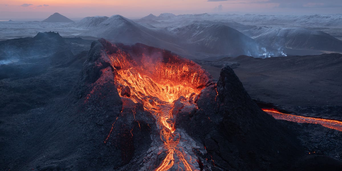
The current concern centers on the Reykjanes Peninsula, a volcanic region that reawakened in 2021 after centuries of relative quiet. Since then, the area has produced multiple eruptions, most of them fissure eruptions. Unlike the postcard image of a cone-shaped volcano blasting ash into the sky, fissure eruptions occur when the ground opens along cracks and lava flows out in glowing sheets, streams, and fountains.
The most watched area right now is Svartsengi, a geothermal and volcanic zone near the town of Grindavík, the Blue Lagoon, and key energy infrastructure. Monitoring data show that magma is still collecting several kilometers below the surface. As magma pushes into underground storage areas, the land above it can rise. That uplift is one of the biggest clues scientists use to estimate pressure in the system.
In recent updates, Icelandic scientists have emphasized that low earthquake activity does not automatically mean the unrest is fading. A volcano can be quiet in the same way a cat can be quiet while staring at a glass of water near the edge of a table. Nothing has happened yet, but everyone in the room knows the situation deserves respect.
What Makes Reykjanes Different From the 2010 Eyjafjallajökull Eruption?
Many people hear “Iceland volcano” and immediately think of the 2010 Eyjafjallajökull eruption, which disrupted air travel across Europe and introduced the world to a volcano name that looked like someone spilled alphabet soup on a keyboard. The Reykjanes activity is different.
The recent Reykjanes eruptions have generally produced lava flows rather than giant ash clouds. That matters because ash is the major threat to aviation. Fine volcanic ash can damage aircraft engines, which is why Eyjafjallajökull caused such widespread flight disruption. By contrast, recent Reykjanes fissure eruptions have mostly affected roads, local communities, utility systems, air quality, and nearby attractions rather than international flight routes.
That said, “less ash” does not mean “no danger.” Lava can cut roads, damage pipelines, threaten buildings, and release volcanic gases. Ground cracks can open suddenly. Gas pollution can collect in low-lying areas, especially when winds are weak. The danger is more local than global, but for people, workers, and infrastructure in the affected zones, local danger is still very real.
The Main Areas at Risk
Grindavík
Grindavík, a fishing town on the southern side of the peninsula, has been one of the most affected communities since the current unrest cycle intensified. The town was largely evacuated in 2023 after major ground deformation, earthquakes, and the threat of magma moving beneath the area. Since then, residents have faced repeated evacuations, uncertainty, property damage, and the emotional toll of living beside a restless volcanic system.
Svartsengi
Svartsengi is important because it is not just a volcanic monitoring keyword; it is also home to vital geothermal infrastructure. The area supports energy and hot water services that matter to nearby communities. Protecting this infrastructure has become a major priority, and defensive barriers have been constructed to reduce the risk of lava reaching critical facilities.
The Blue Lagoon
The Blue Lagoon, one of Iceland’s most famous tourist destinations, is also located in the broader risk area. It has temporarily closed and evacuated guests during previous periods of volcanic activity. Protective barriers have been built around parts of the area, and operators continue to coordinate with official safety guidance. Visitors should not assume that a beautiful geothermal spa is automatically outside nature’s group chat. In Iceland, even the luxury bathwater comes with a geology briefing.
Keflavík International Airport
Keflavík International Airport has remained operational during recent Reykjanes eruptions, and the type of activity expected in this region is not the same as the ash-producing eruption that disrupted European aviation in 2010. Still, travelers should check flight status before departure and monitor official advisories, especially if an eruption begins or volcanic gas affects roads and local access.
How Iceland Is Preparing
1. Constant Scientific Monitoring
Iceland’s preparation starts with data. Scientists track earthquakes, ground deformation, gas emissions, satellite images, tremor signals, and GPS measurements. These tools help experts identify whether magma is accumulating, moving sideways into a dike, or approaching the surface.
One important detail is that warning times can be short. In previous Reykjanes events, signs of an eruption have sometimes appeared only minutes to a few hours before lava reached the surface. That is why Iceland relies on continuous monitoring rather than casual check-ins. Volcanoes do not always RSVP.
2. Hazard Maps and Alert Levels
The Icelandic Meteorological Office has updated its hazard assessment system for the Reykjanes Peninsula. The current mapping approach considers several hazards, including seismic activity, sinkholes, fault movements, eruptive fissures, lava flows, tephra fallout, and gas pollution. The system is designed to show not only where lava may go, but also where other risks could affect people, roads, and infrastructure.
This is especially important because volcanic hazards are not static. A safe-looking area can become risky if wind direction changes, if a fissure opens in a new place, or if lava advances toward roads. Hazard maps help emergency planners, residents, and businesses make decisions before the situation becomes chaotic.
3. Evacuation Planning
Iceland has well-developed emergency procedures for volcanic activity. Authorities can send mobile alerts to people in affected areas, and emergency response plans are designed for different types of disasters. Evacuation routes, road closures, public warnings, and access restrictions can be activated quickly.
The repeated evacuations of Grindavík and the Blue Lagoon show how seriously Iceland treats early warnings. Evacuations may feel inconvenient, especially for tourists who planned a relaxing day in mineral-rich water and instead got a lesson in plate tectonics. But the safety principle is simple: leave early, argue later.
4. Lava Barriers
One of the most visible preparations is the construction of protective barriers. These earthworks are designed to slow, divert, or contain lava flows before they reach towns, roads, power facilities, or tourist infrastructure. Lava barriers are not magic walls, and they cannot guarantee full protection in every scenario. But they can buy time and reduce damage when built in the right places.
In the Svartsengi and Blue Lagoon area, barriers have become part of the landscape. They are a reminder that Icelandic preparedness is not theoretical. Heavy machinery, engineers, geologists, emergency managers, and local authorities have been working to turn scientific forecasts into physical defenses.
5. Public Communication
Clear communication is one of Iceland’s strongest tools. Official agencies publish updates, hazard maps, aviation notices, road information, and emergency guidance. This matters because volcanic unrest attracts rumors faster than lava flows downhill. Social media may show spectacular images, but official sources explain whether an area is open, closed, dangerous, or simply being monitored.
Could the Next Eruption Be Larger?
One reason the current situation is being watched so closely is the volume of magma that has accumulated beneath Svartsengi. Recent official estimates indicate that the amount is higher than before several earlier events in the current eruption sequence. If a large portion of that magma reaches the surface, the next eruption could be larger than some previous Reykjanes eruptions.
However, volcanic forecasting is not the same as setting a kitchen timer. Magma can accumulate without erupting immediately. It can move underground and stall. It can form a dike that never reaches the surface. Or it can erupt quickly after subtle changes. The challenge for scientists is not only estimating how much magma exists, but also understanding whether pressure, rock strength, fracture pathways, and regional stress conditions will allow it to break through.
In practical terms, Iceland is preparing for several possibilities: no eruption in the near term, a small fissure eruption, a larger fissure eruption, gas hazards, lava threats to roads or infrastructure, and short-notice evacuations. Good preparedness does not require knowing the exact future. It requires being ready for the most plausible futures.
What Travelers Should Know
For travelers, the most important point is not to cancel every Iceland dream because of a headline. Iceland is a large country, and volcanic unrest in one region does not automatically affect the whole island. Reykjavík, the Golden Circle, the South Coast, northern Iceland, and many other destinations may continue operating normally depending on conditions.
Still, travelers should be flexible. Check road conditions before driving near Reykjanes. Follow airport and airline updates. Respect closures. Do not walk on fresh lava fields, protective barriers, or restricted roads. Fresh lava can look solid while still being dangerously hot beneath a thin crust. That is not a hiking trail; that is Earth’s frying pan with scenery.
Volcanic gas is another concern. Even when lava is not nearby, sulfur dioxide and other gases can affect air quality. People with asthma, heart conditions, respiratory issues, young children, and older adults should be especially cautious. If authorities warn of gas pollution, take it seriously.
What Residents and Businesses Are Facing
For local residents, this is not just a science story. It is a housing story, an insurance story, a work story, a school story, and a mental health story. Grindavík residents have lived through uncertainty that many outsiders only glimpse through dramatic lava photos. Businesses near the hazard zone have had to adapt to closures, evacuations, access restrictions, and changing visitor confidence.
The situation also highlights Iceland’s dependence on geothermal systems. Geothermal energy is one of the country’s strengths, but in places like Svartsengi, it exists close to the same geologic forces that create volcanic risk. The result is a complicated balancing act: protect critical infrastructure, maintain services, support communities, and prepare for a landscape that can change overnight.
Why This Eruption Cycle Could Last Years
Experts have warned that the Reykjanes Peninsula may be entering a long volcanic cycle. Historical patterns suggest that activity in the region can continue episodically for decades or even centuries. That does not mean constant eruptions. Instead, the region may experience bursts of activity separated by quiet periods, magma intrusions, earthquakes, and occasional lava flows.
This is why officials do not treat a quiet month as the end of the story. A pause can be just that: a pause. The current monitoring strategy reflects that reality. Iceland is preparing not only for the next eruption, but for a future in which volcanic readiness becomes a recurring part of life on Reykjanes.
Experience Section: What It Feels Like to Follow an Iceland Volcano Story
Following a possible volcanic eruption in Iceland is a strange mix of awe, anxiety, and refreshing respect for science. One moment you are looking at a peaceful landscape of moss-covered lava fields, steam rising from geothermal vents, and mountains sitting quietly under a wide northern sky. The next moment, you are reading that the ground has risen by centimeters, magma is accumulating several kilometers down, and emergency officials are updating hazard zones. Iceland has a way of making geology feel less like a textbook chapter and more like a neighbor with heavy footsteps.
For visitors, the experience often begins with curiosity. You land at Keflavík, see black lava fields stretching beside the road, and realize the island is built from forces that are still active. The landscape does not look dead or ancient. It looks paused. That is part of Iceland’s power. Even when nothing is erupting, the terrain feels alive. The steam, the cracked ground, the sharp lava rocks, the warning signs, and the changing road updates all tell the same story: this place is beautiful because it is unfinished.
There is also a lesson in humility. Tourists sometimes want volcanoes to perform on schedule, preferably around sunset and within safe camera distance. Nature, very rudely, does not run a ticketed show. An eruption can begin with little warning, or expected activity can stall underground for months. The smartest travelers learn to trade certainty for awareness. They check official updates, listen to local authorities, and avoid treating restricted zones like adventure playgrounds.
For residents, the experience is deeper and heavier. A glowing lava fountain may look spectacular online, but for a family from Grindavík, it can represent another evacuation, another delay, another worry about a home, a business, or a future that keeps shifting. Volcanic preparedness is not only about helmets, sirens, maps, and barriers. It is also about patience, community support, and the emotional fatigue of living with uncertainty.
What Iceland does exceptionally well is combine seriousness with calm. There is no need for disaster-movie panic. The country has strong monitoring networks, experienced scientists, practical emergency systems, and a public that understands volcanic reality better than most. The mood is not “everything is fine” or “everything is doomed.” It is more mature than that: watch carefully, prepare early, communicate clearly, and respect the mountain even when it is quiet.
That is the main takeaway from Iceland’s current volcanic watch. The possible eruption is not just a dramatic headline; it is a case study in living with a dynamic planet. Iceland cannot stop magma from moving, but it can measure, map, warn, evacuate, redirect, and adapt. In a world that often waits until trouble is already knocking, Iceland is listening while trouble is still underground.
Conclusion
Iceland is preparing for a possible volcanic eruption because the signs beneath Reykjanes are too important to ignore. Continued uplift at Svartsengi, a large accumulated magma volume, and the history of repeated eruptions along the Sundhnúkur crater row all point to an elevated risk of renewed activity. The timing remains uncertain, and an eruption is not guaranteed on any specific day. But the possibility is real enough that Icelandic authorities are maintaining hazard assessments, monitoring the area around the clock, protecting infrastructure, and keeping evacuation systems ready.
For travelers, the message is simple: stay informed, stay flexible, and follow official guidance. For residents, the situation remains a long-term challenge that blends science, safety, infrastructure, and resilience. For everyone else watching from afar, Iceland offers a powerful reminder that the Earth is not a finished product. Sometimes it edits itself in glowing orange.